Pittsburgh and Allegheny
Item
Title
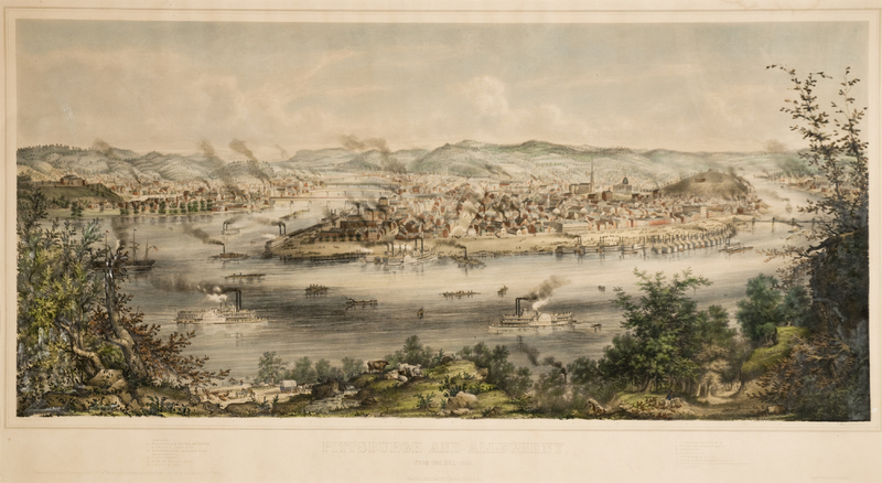
Pittsburgh and Allegheny
Creator
Benjamin Franklin Smith
American, 1830–1927
Printed by Tappan & Bradford, Boston
Published by G. Warren Smith & Co., New York
American, 1830–1927
Printed by Tappan & Bradford, Boston
Published by G. Warren Smith & Co., New York
Date
1849
Materials
Lithograph with hand coloring
Measurements
25-11/16 x 44-1/4 in. (65.2 x 112.4 cm
Description
The Smith brothers owe their introduction to the view making business to Edwin Whitefield. Francis and George Warren Smith worked as agents for Whitefield—they sold subscriptions in the various towns and cities he drew—as early as 1846, and Benjamin Franklin Smith, a one-time student of Whitefield’s, began collaborating with the artist on imagery a few years later. Interestingly, this lithograph of Pittsburgh and Allegheny City may mark the very point when the employees became competitors. In April 1848, Whitefield and George Warren Smith canvassed Pittsburgh together in order to produce a view of the city. Whitefield made sketches while Smith solicited the three hundred subscriptions necessary to render the project profitable. The following summer, unbeknownst to Whitefield, Smith was back in Pittsburgh to further promote the final drawing—by his brother, B. F. Smith! Whitefield, of course, was furious about the turn of events, but there was little he could do. The Smith’s effort, according to all concerned, was far superior to Whitefield’s, which in the end was also published, but later, in 1850.
The vantage point for this view of Pittsburgh and Allegheny City (in 1849 still a separate municipality) is the elevated area across the Monongahela River from Pittsburgh known today as Mt. Washington. In the later eighteenth century, though, and for much of the nineteenth, it was known as Coal Hill. As early as 1760 bituminous coal was mined along its side, about 200 feet above the river, to supply Fort Pitt. Before long, the hill was recognized as the proverbial tip of the iceberg, the iceberg being in this instance the mammoth Pittsburgh coal seam, source of the finest coal in America for the production of coke, the fuel for the nation’s steel industry.
The vantage point for this view of Pittsburgh and Allegheny City (in 1849 still a separate municipality) is the elevated area across the Monongahela River from Pittsburgh known today as Mt. Washington. In the later eighteenth century, though, and for much of the nineteenth, it was known as Coal Hill. As early as 1760 bituminous coal was mined along its side, about 200 feet above the river, to supply Fort Pitt. Before long, the hill was recognized as the proverbial tip of the iceberg, the iceberg being in this instance the mammoth Pittsburgh coal seam, source of the finest coal in America for the production of coke, the fuel for the nation’s steel industry.
Source
Palmer Museum of Art, The Pennsylvania State University, partial gift and purchase from John C. O’Connor and Ralph M. Yeager.
Identifier
86.547
Rights
This image is posted publicly for non-profit educational uses, excluding printed publication. Other uses are not permitted.

